PAGASA: Habagat & LPA to Bring Cloudy Skies & Rains Over Parts of Ph
The state weather bureau PAGASA reported that the habagat and low-pressure area will bring cloudy to rainy condition over some parts of the country.
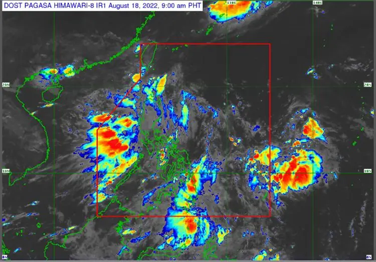
On Thursday (August 18, 2022), the Philippine Atmospheric, Geophysical and Astronomical Services Administration (Pagasa) released the latest weather update in the country. The habagat and low-pressure area will affect the country’s weather condition.
PAGASA reported that a low-pressure area has been last spotted at 210 kilometers northeast of Tuguegarao City, Cagayan or 160 km east of Calayan, Cagayan. The habagat will be affecting the western sections of northern and central Luzon.
The low-pressure area and southwest monsoon will bring cloudy skies with scattered rain showers and thunderstorms over Ilocos Region, Cordillera Administrative Region, Batanes, Cagayan, Isabela, Zambales, Bataan, Aurora, and Quezon.
“Sa ngayon, within the next three days ay wala naman tayong inaasahan na bagyo dahil nga itong ating LPA ay maliit ang tsansa na maging bagyo,” Pagasa weather specialist Raymond Ordinario said.
Ordinario said that the LPA has a slin chance of developing into a tropical depression in the next three days.
The southwest monsoon and the localized thudnerstorms will bring partly cloudy to cloudy condition with isolated rainshowers or thunderstorms over Bicol Region, Northern Samar, Oriental Mindoro, Marinduque and Romblon as well as Metro Manila and the rest of the country.
Meanwhile, the coastal water condition over Luzon, Visayas, and Mindanao will be slight to moderate, according to the weather bureau.
The weather agency has warned the residents in the affected areas for possible flash floods or landslides due to moderate to at times heavy rains.